
MAKARA CATCHMENT
Primary township Elsthorpe
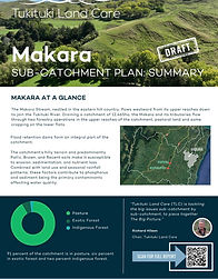
Area 12,465ha
Land use: 91 percent of the catchment is in pasture, six percent in exotic forest and two percent indigenous forest.
CATCHMENT
GROUP
Committee members Andrew Thomas, Kate Laugesen, Tim Forde, Ray Munn, Richard Scott
Co-Chairs Andrew Thomas and Kate Laugesen
Catchment Co-ordinator Pixie Seligman
Email tukicoordinator@gmail.com
Phone 0277212423


ABOUT OUR CATCHMENT
THE BIG PICTURE
The Big Picture
As part of The Big Picture project, TLC has developed independent, science-backed catchment plans for each of the 17 sub-catchments of the Tukituki River. These farmer-led plans address key environmental challenges specific to each area while identifying practical, affordable solutions. These plans do not impose rules or regulations but they give farmers and catchment groups a roadmap for future planning to improve water quality, boost farm productivity, and open the door to future funding opportunities.
TLC partnered with environmental planning consultancy Environment, Innovation and Strategy Ltd (EIS), who collected data specific to each sub-catchment, including erosion maps, flow path models, land use capability, soil types, and water monitoring information. Alongside the scientific data, in December 2024, TLC hosted workshops for farmers and growers in each sub-catchment to make sure the solutions aligned with the realities of farming and growing in each sub-catchment.
Makara Draft Sub-Catchment Plan: Summary
Makara Draft Sub-Catchment Plan: Full Report

Makara Catchment Maps

TLC FARMER TOOLBOX
Tools for the Makara Catchment
As part of The Big Picture, TLC has developed the TLC Farmer Toolbox, designed to support landowners in making informed decisions and enable them to implement changes with confidence, ensuring that time and money are invested wisely.
The TLC Toolbox includes the following:
-
TLC’s On-Farm Action Planning Tool - prioritise on-farm environmental actions based on their cost-effectiveness and impact.
-
TLC’s Plant Selection Tool - choose the right plants for on-farm environmental projects by matching your planting zone and purpose with suitable species.
-
TLC’s Surface Erosion Tool - determine the most erosion-prone areas on your farm to identify priority sites for effective soil conservation measures.
-
TLC’s Water Runoff Mapping Tool - identify sites for on-farm edge-of-field mitigations such as sediment traps, constructed wetlands and detention bunds.
-
TLC’s Riparian Mapping Tool - better understand riparian condition and vegetation class along waterways to prioritise where riparian management should occur.
-
TLC’s ETS Guide- download TLC’s ETS Guide for key information on the Emissions Trading Scheme, including its purpose, benefits, eligibility, enrolment process, and potential costs and returns.
-
TLC’s Willow Management Guide - download TLC’s Invasive Willow Management Guide for insights on willows in the Tukituki, control strategies and riparian restoration.
-
TLC’s List Of Advisors - connect with local advisors for tailored advice and potential funding opportunities.
TLC DEMONSTRATION PROJECT
Project Summary
In September 2023, TLC awarded a $10,000 Demonstration Grant to the Makara Catchment Group to carry out a whole catchment assessment to celebrate successes and give direction for future actions.
Twenty-five landowners from the Makara sub-catchment participated in the study, representing a land area of 14,806 hectares.
Outcomes
1. State of the Nation Report
A final report produced by agricultural consultants KS Agri offers valuable insights into environmental challenges and opportunities in this sub-catchment, gleaned from farmer interviews, analysis of Farm Environmental Management Plans, and mapping.


The report not only explores key indicators such as DIN, phosphorus, and turbidity but also provides insights into a wide range of data, including erosion pole planting, wetland creation, and riparian fencing.
The report also offers actionable recommendations, including increasing the number of water testing sites and managing existing sediment traps and dams.
In addition to providing valuable and actionable data for the farmers in this catchment, the study also served as a unifying force, bringing together farmers in the area. At the conclusion of the project the farmers and their families gathered at the Elsthorpe Hall to share a beer and sausage sizzle and hear a presentation by KS Agri on the preliminary findings.

2. Water Testing Programme
In September 2024, TLC agreed to commence a 12 month water monitoring programme at four sites in the Makara sub-catchment as recommended in the KS Agri Report.
For more information, please get in touch with Pixie Seligman.
MAKARA STATE OF THE NATION - MARCH 2024
The full report on the Makara sub-catchment produced by KS Agri and funded by a TLC Demonstration Grant is now available to download.
The report includes a catchment overview, water quality data and soil types, the collective footprint as well as a recommendations by KS Agri.

Farms that were part of the project ranged from 60ha to 3751ha. Most of the farms were dry stock operations with some cash cropping on the flats along with two forestry blocks.
The total cropped area of the catchment was 3% (434ha) and of that winter cropping accounted for 0.34% with only four farms choosing to put in winter crops. Only two farms had irrigation for a total of 87ha under gun irrigators.
61% of the farms had sediment dams on their property. The catchment has 12% of its land area under production forestry with around 30ha due to be harvested in the next 5 years.
25 Farms Involved
14,806 ha
Average Stocking
Rate 8.0 su/ha
N Loss
14.7 kgN/ha
P Loss
0.78kgP/ha

MAKARA
COLLECTIVE FOOTPRINT
As at March 2024:
8,767 erosion poles planted since 2018
63ha of wetlands fenced over 8 farms
54.5km of riparian fencing completed
0.5% (97ha) of the catchment is in QEII
110ha of native bush and regenerating Manuka


